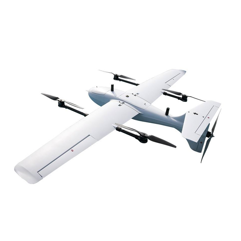


1080P Camera Fixed Wing Inspection Drones for Mapping
1080P Camera Fixed Wing Inspection Drones for Mapping are designed for professional surveying, inspection, and mapping applications that require long flight range and stable performance. The fixed wing structure provides high aerodynamic efficiency, allowing the drone to cover large areas in a single mission. Equipped with a 1080P full HD camera, the drone captures clear and detailed aerial images for mapping and inspection tasks. The platform supports stable cruising at high altitude, with a maximum operating height of up to 5000 meters.
$9.10
CompareTechnical Specifications:Inspection Drones
| Material | Plastic |
| Video capture resolution | 1080p Full HD |
| Maximum flight altitude | 5000 meters |
| Maximum flight speed | 30 meters per second |
Product Introduction
1080P Camera Fixed Wing Inspection Drones for Mapping are designed for professional surveying, inspection, and mapping applications that require long flight range and stable performance. The fixed wing structure provides high aerodynamic efficiency, allowing the drone to cover large areas in a single mission. Equipped with a 1080P full HD camera, the drone captures clear and detailed aerial images for mapping and inspection tasks. The platform supports stable cruising at high altitude, with a maximum operating height of up to 5000 meters. Advanced flight control ensures smooth flight, accurate route tracking, and reliable data collection. The drone is suitable for long-distance remote control operations with consistent signal stability. Durable airframe construction allows operation in complex outdoor environments. The system supports mapping, terrain surveying, and infrastructure inspection tasks. Simple operation and clear control logic make it suitable for both professional users and training purposes. By combining image clarity, endurance, and flight stability, this fixed wing inspection drone improves data accuracy and operational efficiency.
Application Scenarios
Related products
-
Inspection Drones
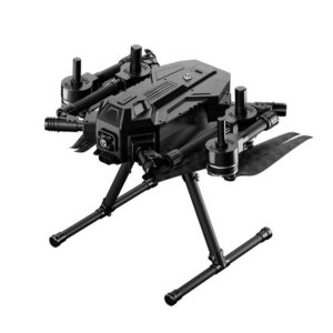
5G Networked Industrial Inspection Drones for Remote Monitoring
5G Networked Industrial Inspection Drones for Remote Monitoring are designed for demanding industrial inspection tasks that require real-time data transmission and reliable performance. The drone integrates a 5G communication module to enable high-speed, low-latency data transfer during flight operations. This allows live video streaming, remote control, and instant data analysis from long distances. The industrial-grade airframe provides strong structural stability and supports continuous operation in complex environments. Advanced inspection payloads can be mounted to support magnetic anomaly detection, visual inspection, and sensor-based monitoring.
SKU: n/a -
Inspection Drones
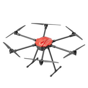
Commercial Fixed Wing Inspection Drones with 5kg Payload
Commercial Fixed Wing Inspection Drones with 5kg Payload are designed for professional inspection, mapping, and educational applications that require long endurance and stable flight performance. The fixed wing design provides high aerodynamic efficiency, allowing longer flight time and wider coverage compared to multi-rotor drones. With a maximum payload capacity of 5 kilograms, the drone can carry inspection sensors, cameras, and mapping equipment with ease. A reliable flight control system ensures stable cruising and precise route execution.
SKU: n/a -
Inspection Drones
Long Range 4K Camera Inspection Drones for Remote Monitoring
Long Range 4K Camera Inspection Drones for Remote Monitoring are designed for professional inspection and surveillance tasks that require stable flight and clear visual data. The drone is equipped with a high-resolution 4K camera that captures detailed images and videos for accurate inspection results. Integrated GPS navigation ensures precise positioning, stable hovering, and reliable route planning during long-distance operations. The quadcopter structure with brushless motors provides smooth flight performance and strong power output. Long-range transmission allows operators to monitor targets from extended distances in real time.
SKU: n/a -
Inspection Drones
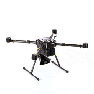
High-Power 1300W Inspection Drones with GPS Navigation
High-Power 1300W Inspection Drones with GPS Navigation are designed for professional inspection tasks that require strong power, stable flight, and accurate positioning. The drone is equipped with a 1300W high-power propulsion system and operates on a 22.2V power platform, providing strong lift capability and reliable performance during long inspection missions. Integrated GPS navigation supports precise positioning, route planning, and stable hovering, which improves inspection accuracy and flight safety. The platform supports the installation of visual cameras and thermal imaging sensors for multi-angle data collection. This allows effective inspection of power lines, agricultural fields, and urban infrastructure.
SKU: n/a